NJDEP and FEMA Release Revised Flood Maps for Morris County
Updated Flood Maps Begin Formal Adoption Process and Outline Current Flood Risk
The New Jersey Department of Environmental Protection (NJDEP) and the Federal Emergency Management Agency (FEMA) have released revised preliminary Flood Insurance Rate Maps (pFIRMs) and an updated Flood Insurance Study (FIS) for Morris County, formally beginning the federal map adoption process.
Once adopted, the revised flood maps will be used to determine flood insurance requirements and eligibility for disaster relief and mitigation funding. The maps also serve as the most reliable source of flood risk information for communities, particularly when evaluating future development and planning decisions.
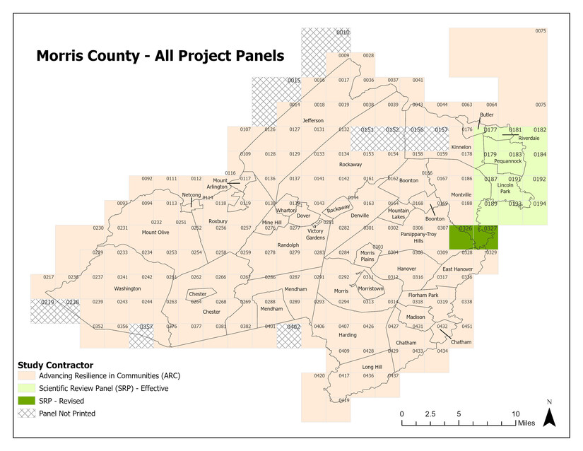
The revised pFIRMs and FIS do not include changes to most waterways reviewed through the Scientific Resolution Panels (SRP) process, which became effective Aug. 19, 2025. Those SRP-effective areas are shown in light green on the “Morris County -- All Projects Panels” graphic included with this release.
The map also identifies the Advancing Resilience in Communities areas incorporated into the revised products, including two SRP-Revised panels that contain additional waterways not previously studied through the SRP process and shown in dark green.
Paper copies of the revised documents have been distributed to each municipality and are available for public review through local municipal offices. Municipal contact information is available on the county website.
The revised maps, study report and associated data also are available for download and digital viewing through FEMA’s Map Service Center and FEMA’s online data viewer.
NJDEP and FEMA will hold a Consultation Coordination Officer meeting with municipal officials and consultants on Jan. 8, 2026. That meeting will be followed by two public open houses where residents can speak directly with state and federal officials about updated flood hazard information. The first open house will be held Jan. 8, 2026 from 3 to 7 p.m. at the Morris County Public Safety Training Academy, 500 W. Hanover Ave., Morristown. A second open house will be held Jan. 13, 2026 from 4 to 8 p.m. at the Chester Library, 250 West Main Street, Chester.
Because the revised maps will guide flood risk determinations for the foreseeable future, Morris County encourages affected municipalities and property owners to attend an open house to learn about the maps, approval timelines and the process for requesting map changes if inaccuracies are identified.
The Morris County Flood Mitigation Program will continue to provide updates throughout the adoption process. Additional information, including map resources, meeting schedules and contact information, is available on the county’s Flood Insurance Rate Maps webpage.
Residents with questions may contact a FEMA map specialist by calling 877-FEMA-MAP (1-877-336-2627) from 8 a.m. to 7 p.m. on weekdays. A live chat feature is also available from 9 a.m. to 5 p.m., along with additional resources, on the FEMA website. Questions also can be emailed to FEMA-FMIX@fema.dhs.gov, or to Morris County Flood Mitigation Program Coordinator Mike DiGiulio: mdigiulio@co.morris.nj.us.