Image
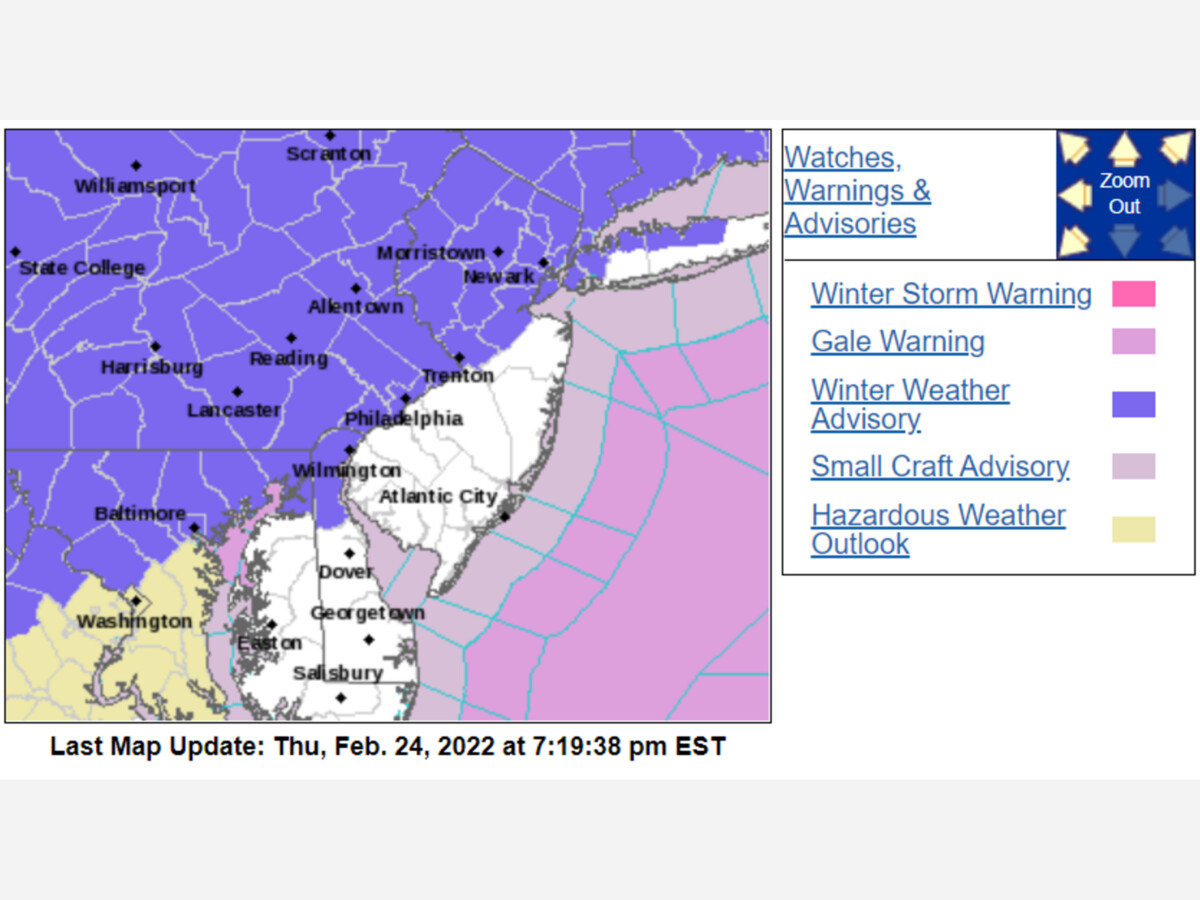

Tonight, a chance of sleet and snow between 10 PM and 11 PM with a total overnight snow accumulation of 1 to 2 inches possible.
Winter Weather Advisory today to 1 PM Friday.
*From the National Weather Service
URGENT - WINTER WEATHER MESSAGE
National Weather Service Mount Holly NJ
323 PM EST Thu Feb 24 2022
NJZ007>010-PAZ060>062-105-250930-
/O.CON.KPHI.WW.Y.0012.220225T0000Z-220225T1800Z/
Warren-Morris-Hunterdon-Somerset-Berks-Lehigh-Northampton-
Upper Bucks-
Including the cities of Washington, Morristown, Flemington,
Somerville, Reading, Allentown, Bethlehem, Easton, Chalfont,
and Perkasie
...WINTER WEATHER ADVISORY REMAINS IN EFFECT FROM 7 PM THIS
EVENING TO 1 PM EST FRIDAY...
* WHAT...Mixed precipitation expected. Total snow and sleet accumulations
of up to two inches and ice accumulations of one tenth to one
quarter of an inch.
* WHERE...The New Jersey counties of Warren and Morris. The
Pennsylvania counties of Berks, Lehigh and Northampton.
* WHEN...From 7:00 PM this evening until 1:00 PM Friday.
* IMPACTS...Local power outages and tree damage are possible due
to the ice. Travel could become very difficult. The hazardous
conditions are expected to impact the Friday morning commute.
PRECAUTIONARY/PREPAREDNESS ACTIONS...
Slow down and use caution while traveling.
Tomorrow, snow, freezing rain, and more rain to mid-afternoon. The weekend looks cold but dry.
...
Rain (or freezing rain with a chance of 1–2 in. of snow) in the morning (until 11 AM) and afternoon (until 3 PM).
High: 47° Low: 18° with a 90% chance of rain with 9 mph winds from the NNW.
Partly cloudy throughout the day. Highs just above freezing.
High: 38° Low: 26° with a 4% chance of precipitation with 7 mph winds from the WNW.
Clear throughout the day.
High: 44° Low: 18° with a 22% chance of rain with 11 mph winds from the W.
-
There you have it! For more details, check out our weekly weather forecast.


Sunny, with a high of 40 and low of 19 degrees. Sunny in the morning, overcast during the afternoon and evening, clear overnight.